
Waihona:Huahine topographic map-fr.svg

Size of this PNG preview of this SVG file: 516 × 600 mau pikela. Other resolutions: 206 × 240 mau pikela | 413 × 480 mau pikela | 661 × 768 mau pikela | 881 × 1,024 mau pikela | 1,762 × 2,048 mau pikela | 714 × 830 mau pikela.
Waihona kumu (Waihona SVG, 714 x 830 mau pikela, nui waihona: 536 KB)
Hōʻuluʻulu manaʻo
| Description |
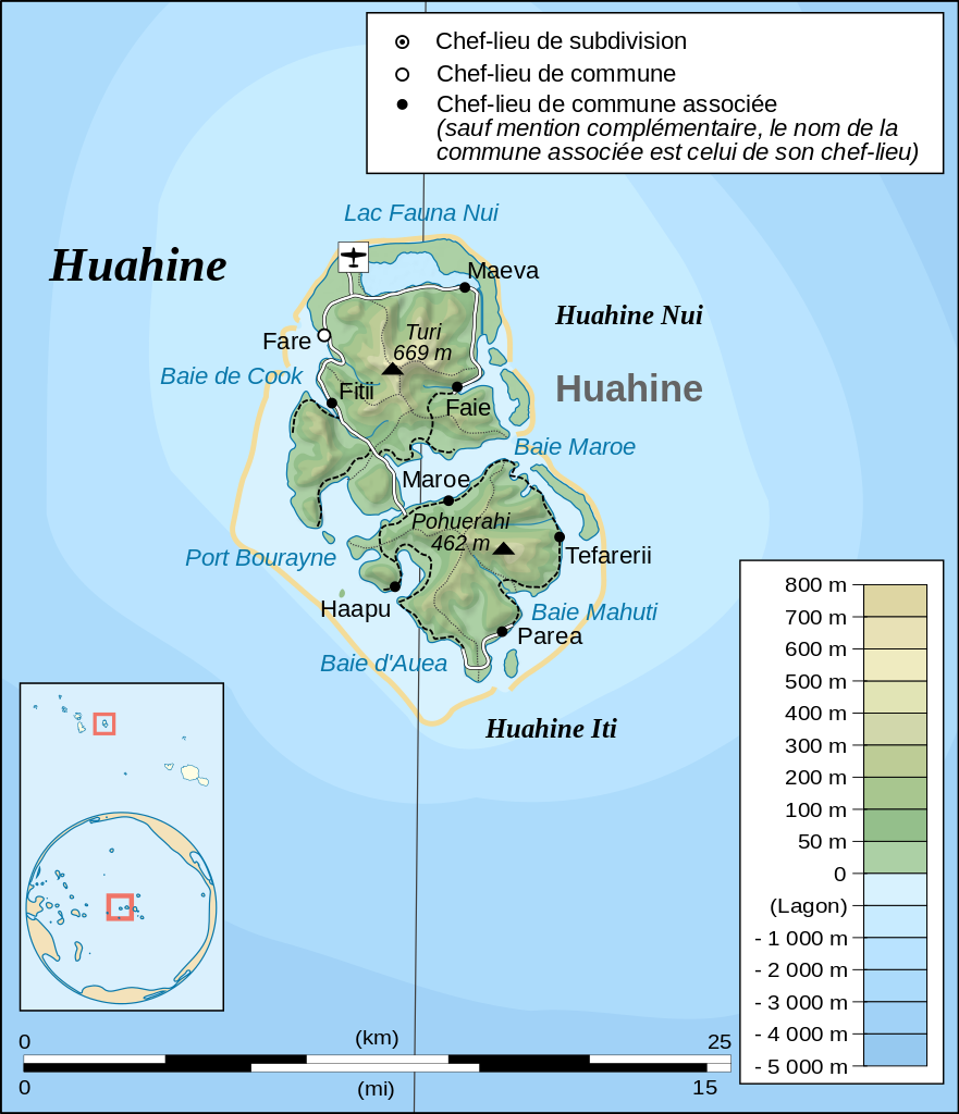
English: Topographic map in French of the island of Huahine, Society Islands, French Polynesia.
Français : Carte topographique en français de l'île de Huahine, îles de la Société, Polynésie Française. |
| Date | |
| Source |
Œuvre personnelle.
Données :
Logiciels utilisés :
Autres informations :
|
| Author | Sardon |
| Other versions | Macedonian |
Laikini
| I, the copyright holder of this work, release this work into the public domain. This applies worldwide. In some countries this may not be legally possible; if so: I grant anyone the right to use this work for any purpose, without any conditions, unless such conditions are required by law. |
Mōʻaukala waihona
Kāomi ma ka lā/hola no ka nānā ʻana i ka waihona ma kēlā manawa.
| Lā/Hola | Kiʻiliʻi | Nā Nui | Mea ho‘ohana | Kaumanaʻo | |
|---|---|---|---|---|---|
| okamanawa | 09:25, 9 Nowemapa 2008 | | 714 × 830 (536 KB) | Sardon | {{Information |Description= |Source= |Date= |Author= |Permission= |other_versions= }} |
| 09:24, 9 Nowemapa 2008 |  | 714 × 1,143 (533 KB) | Sardon | Reverted to version as of 09:22, 9 November 2008 | |
| 09:23, 9 Nowemapa 2008 |  | 714 × 1,143 (533 KB) | Sardon | {{Information |Description= |Source= |Date= |Author= |Permission= |other_versions= }} | |
| 09:22, 9 Nowemapa 2008 |  | 714 × 1,143 (533 KB) | Sardon | {{Information |Description={{en|1=Topographic map in French of the island of Huahine, Society Islands, French Polynesia.}} {{fr|1=Carte topographique en français de l'île de Huahine, îles de la Société, Polynésie Fran |
Nā Hana waihona
Loulou kekahi ‘ao‘ao i kēia waihona:
Global file usage
The following other wikis use this file:
- Usage on als.wikipedia.org
- Usage on da.wikipedia.org
- Usage on de.wikipedia.org
- Usage on en.wikipedia.org
- Usage on eo.wikipedia.org
- Usage on es.wikipedia.org
- Usage on fi.wikipedia.org
- Usage on fr.wikipedia.org
- Usage on gl.wikipedia.org
- Usage on hu.wikipedia.org
- Usage on id.wikipedia.org
- Usage on it.wikipedia.org
- Usage on lt.wikipedia.org
- Usage on mk.wikipedia.org
- Usage on no.wikipedia.org
- Usage on pl.wikipedia.org