
Waihona:Fiji location map.svg

Size of this PNG preview of this SVG file: 467 × 599 mau pikela. Other resolutions: 187 × 240 mau pikela | 374 × 480 mau pikela | 599 × 768 mau pikela | 798 × 1,024 mau pikela | 1,596 × 2,048 mau pikela | 728 × 934 mau pikela.
Waihona kumu (Waihona SVG, 728 x 934 mau pikela, nui waihona: 144 KB)
Hōʻuluʻulu manaʻo
| Description |
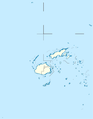
Deutsch: Positionskarte von Fidschi
Quadratische Plattkarte, N-S-Streckung 104 %. Geographische Begrenzung der Karte:
English: Location map of Fiji
Equirectangular projection, N/S stretching 104 %. Geographic limits of the map:
|
| Date | |
| Source |
Own work, using
|
| Author | NordNordWest |
| Permission (Reusing this file) |
I, the copyright holder of this work, hereby publish it under the following license: This file is licensed under the Creative Commons Attribution-Share Alike 3.0 Unported license.
|
| Other versions |
Derivative works of this file: |


|
This map has been made or improved in the German Kartenwerkstatt (Map Lab). You can propose maps to improve as well.
|
Mōʻaukala waihona
Kāomi ma ka lā/hola no ka nānā ʻana i ka waihona ma kēlā manawa.
| Lā/Hola | Kiʻiliʻi | Nā Nui | Mea ho‘ohana | Kaumanaʻo | |
|---|---|---|---|---|---|
| okamanawa | 10:19, 19 Kepakemapa 2011 | | 728 × 934 (144 KB) | NordNordWest | corr |
| 16:04, 11 'Okakopa 2009 |  | 728 × 934 (218 KB) | NordNordWest | {{int:filedesc}} {{Information |Description= {{de|Positionskarte von Fidschi}} Quadratische Plattkarte, N-S-Streckung 104 %. Geographische Begrenzung der Karte: * N: 12.3° S * S: 21.8° S * W: 174.4° O * O: 177.9° W {{en|Location map of |
Nā Hana waihona
ʻAʻohe ʻaoʻao e loulou i kēia waihona.
Global file usage
The following other wikis use this file:
- Usage on af.wikipedia.org
- Usage on an.wikipedia.org
- Usage on ar.wikipedia.org
- Usage on arz.wikipedia.org
- Usage on ast.wikipedia.org
- Usage on azb.wikipedia.org
- Usage on az.wikipedia.org
- Usage on ba.wikipedia.org
- Usage on be-tarask.wikipedia.org
- Usage on be.wikipedia.org
- Usage on bg.wikipedia.org
View more global usage of this file.