
Waihona:Vietnam relief location map.jpg

Ka nui o kēia nāmua: 306 × 599 mau pikela. Other resolutions: 122 × 240 mau pikela | 245 × 480 mau pikela | 392 × 768 mau pikela | 1,200 × 2,349 mau pikela.
Waihona kumu (1,200 x 2,349 pikela, nui waihona: 1.68 MB, ʻano MIME: image/jpeg)
Hōʻuluʻulu manaʻo
| Description |
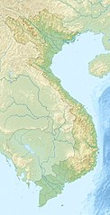
English: Location map of Vietnam.
Equirectangular projection. Strechted by 104.0%. Geographic limits of the map: * N: 24.0° N * S: 8.0° N * W: 101.8° E * E: 110.3° EMade with Natural Earth. Free vector and raster map data @ naturalearthdata.com. |
| Date | |
| Source | Own work |
| Author | Uwe Dedering |
| Other versions |
Derivative works of this file:
|

Laikini
I, the copyright holder of this work, hereby publish it under the following licenses:
This file is licensed under the Creative Commons Attribution-Share Alike 3.0 Unported license.
- You are free:
- to share – to copy, distribute and transmit the work
- to remix – to adapt the work
- Under the following conditions:
- attribution – You must give appropriate credit, provide a link to the license, and indicate if changes were made. You may do so in any reasonable manner, but not in any way that suggests the licensor endorses you or your use.
- share alike – If you remix, transform, or build upon the material, you must distribute your contributions under the same or compatible license as the original.

|
Permission is granted to copy, distribute and/or modify this document under the terms of the GNU Free Documentation License, Version 1.2 or any later version published by the Free Software Foundation; with no Invariant Sections, no Front-Cover Texts, and no Back-Cover Texts. A copy of the license is included in the section entitled GNU Free Documentation License. |
You may select the license of your choice.
Mōʻaukala waihona
Kāomi ma ka lā/hola no ka nānā ʻana i ka waihona ma kēlā manawa.
| Lā/Hola | Kiʻiliʻi | Nā Nui | Mea ho‘ohana | Kaumanaʻo | |
|---|---|---|---|---|---|
| okamanawa | 10:30, 24 'Apelila 2010 | | 1,200 × 2,349 (1.68 MB) | Uwe Dedering | {{Information |Description={{en|1=Location map of Vietnam. Equirectangular projection. Strechted by 104.0%. Geographic limits of the map: * N: 24.0° N * S: 8.0° N * W: 101.8° E * E: 110.3° E Made with Natural Earth. Free vector and raster map da |
Nā Hana waihona
ʻAʻohe ʻaoʻao e loulou i kēia waihona.
Global file usage
The following other wikis use this file:
- Usage on als.wikipedia.org
- Usage on am.wikipedia.org
- Usage on ar.wikipedia.org
- Usage on ast.wikipedia.org
- Usage on az.wikipedia.org
- Usage on ban.wikipedia.org
- Usage on ba.wikipedia.org
- Usage on bcl.wikipedia.org
- Usage on be.wikipedia.org
- Usage on bg.wikipedia.org
View more global usage of this file.