
Waihona:Angola Topography.png

Ka nui o kēia nāmua: 570 × 600 mau pikela. Other resolutions: 228 × 240 mau pikela | 456 × 480 mau pikela | 730 × 768 mau pikela | 973 × 1,024 mau pikela | 1,318 × 1,387 mau pikela.
Waihona kumu (1,318 x 1,387 pikela, nui waihona: 2.41 MB, ʻano MIME: image/png)
Hōʻuluʻulu manaʻo
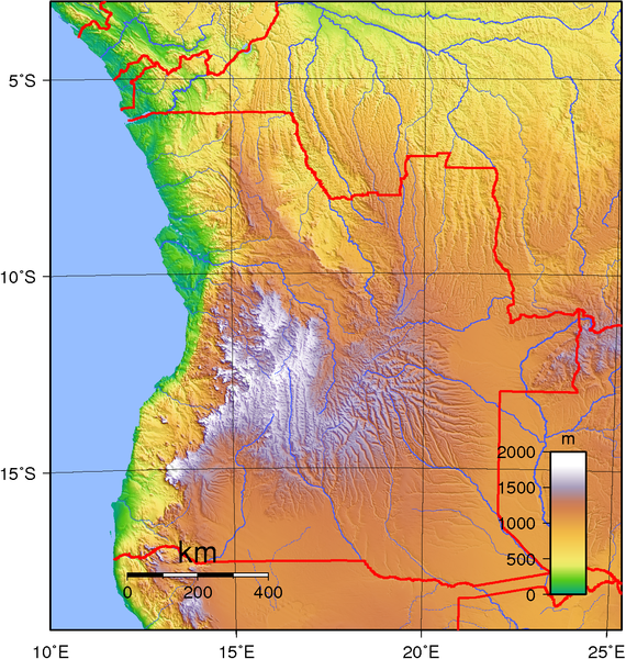
| Description | Topographic map of Angola. Created with GMT from public domain GLOBE data. |
| Date | |
| Source | Own work |
| Author | Sadalmelik |
Laikini
| This work has been released into the public domain by its author, I, Sadalmelik. This applies worldwide. In some countries this may not be legally possible; if so: I, Sadalmelik grants anyone the right to use this work for any purpose, without any conditions, unless such conditions are required by law. |
Mōʻaukala waihona
Kāomi ma ka lā/hola no ka nānā ʻana i ka waihona ma kēlā manawa.
| Lā/Hola | Kiʻiliʻi | Nā Nui | Mea ho‘ohana | Kaumanaʻo | |
|---|---|---|---|---|---|
| okamanawa | 18:58, 29 Iune 2007 | | 1,318 × 1,387 (2.41 MB) | Sadalmelik | better data/colours |
| 21:46, 21 Iune 2007 |  | 1,313 × 1,387 (2.08 MB) | Sadalmelik | {{Information |Description=Topographic map of Angola. Created with GMT from public domain GLOBE data. |Source=self-made |Date=June 21, 2007 |Author= Sadalmelik }} Category:Maps of Angola Category:Topographic maps of Africa |
Nā Hana waihona
Loulou kekahi ‘ao‘ao i kēia waihona:
Global file usage
The following other wikis use this file:
- Usage on af.wikipedia.org
- Usage on ast.wikipedia.org
- Usage on bg.wikipedia.org
- Usage on bn.wikipedia.org
- Usage on ca.wikipedia.org
- Usage on da.wikipedia.org
- Usage on el.wikipedia.org
- Usage on en.wikipedia.org
- Usage on eo.wikipedia.org
- Usage on es.wikipedia.org
- Usage on et.wikipedia.org
- Usage on fa.wikipedia.org
- Usage on hu.wikipedia.org
- Usage on id.wikipedia.org
- Usage on ig.wikipedia.org
- Usage on io.wikipedia.org
- Usage on it.wikipedia.org
- Usage on ja.wikipedia.org
- Usage on ka.wikipedia.org
- Usage on kn.wikipedia.org
- Usage on lt.wikipedia.org
- Usage on mdf.wikipedia.org
- Usage on mzn.wikipedia.org
- Usage on nn.wikipedia.org
- Usage on pt.wikipedia.org
- Usage on ro.wikipedia.org
- Usage on si.wikipedia.org
- Usage on sr.wikipedia.org
- Usage on sv.wikipedia.org
- Usage on szy.wikipedia.org
- Usage on trv.wikipedia.org
- Usage on tum.wikipedia.org
- Usage on uk.wikipedia.org
- Usage on vep.wikipedia.org
- Usage on zh.wikipedia.org