
Waihona:Bhutan - Location Map (2013) - BTN - UNOCHA.svg

Waihona kumu (Waihona SVG, 250 x 250 mau pikela, nui waihona: 520 KB)
_-_BTN_-_UNOCHA.svg)
Arunachal Pradesh shown separately is integral part of India.
Hōʻuluʻulu manaʻo
| Description |
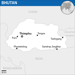
English: Locator map of Bhutan. |
| Date | |
| Source |
English: Bhutan Locator Map (ReliefWeb), ESRI, UNCS, The Times Atlas of the World |
| Author | |
| SVG genesis |
Laikini
- You are free:
- to share – to copy, distribute and transmit the work
- to remix – to adapt the work
- Under the following conditions:
- attribution – You must give appropriate credit, provide a link to the license, and indicate if changes were made. You may do so in any reasonable manner, but not in any way that suggests the licensor endorses you or your use.
 This map is part of a collection of 216 free country maps, created by the UN Office for the Coordination of Humanitarian Affairs (OCHA), to be used in print, web or broadcast products.
The ReliefWeb Location Maps released here are maps that highlight a country, its capital, major populated places and the surrounding regions. Attribution Requirements
Using the map without modifications: ensure that the sources and the disclaimer are below the map. Credit as follows: "Credit: OCHA". For use with alteration: remove the OCHA logo and disclaimer following any modification to the map, but keep the data sources as mentioned below the map. Credit the modified map as follows: "Based on OCHA map". You are responsible for the content of your map. We are keen to receive your feedback and hear how you used OCHA's maps. We would be grateful if you would notify us by e-mail and share your work with us. UN Disclaimer
The designations employed and the presentation of material of this map do not imply the expression of any opinion whatsoever on the part of the Secretariat of the United Nations concerning the legal status of any country, territory, city or area or of its authorities or concerning the delimitation of its frontiers or boundaries. |

|
Textual information (e.g. timestamp) once visible in the image itself has been moved into the image metadata and/or image description page. This makes the image easier to reuse and more language-neutral, and makes the text easier to process and search for. Commons discourages placing visible textual information in images. All licenses accepted on Commons permit this type of modification as a derivative work.
If attribution information were removed and the image is not public domain, replace this tag with {{Attribution metadata from licensed image}}.
|
Mōʻaukala waihona
Kāomi ma ka lā/hola no ka nānā ʻana i ka waihona ma kēlā manawa.
| Lā/Hola | Kiʻiliʻi | Nā Nui | Mea ho‘ohana | Kaumanaʻo | |
|---|---|---|---|---|---|
| okamanawa | 23:38, 25 Kekemapa 2022 | | 250 × 250 (520 KB) | Wikijahnn | File uploaded using svgtranslate tool (https://svgtranslate.toolforge.org/). Added translation for ca. |
| 01:17, 19 Nowemapa 2022 |  | 250 × 250 (520 KB) | Pengetik-AM | File uploaded using svgtranslate tool (https://svgtranslate.toolforge.org/). Added translation for id. | |
| 06:12, 5 Ianuali 2016 |  | 250 × 250 (519 KB) | Wereldburger758 | Resized page to drawing. Removal watermark. Validation of image. | |
| 22:43, 13 Malaki 2014 |  | 254 × 254 (514 KB) | UN OCHA maps bot | == {{int:filedesc}} == {{Information |description={{en|1=Locator Map of Bhutan. {{OCHA map}}}} |date=2013 |source=[http://reliefweb.int/map/bhutan/bhutan-location-map-2013 Bhutan Locator Map (ReliefWeb)] |author=[[w:United Nations Office f... |
Nā Hana waihona
Loulou kekahi ‘ao‘ao i kēia waihona:
Global file usage
The following other wikis use this file:
- Usage on az.wiktionary.org
- Usage on bn.wikipedia.org
- Usage on ca.wikipedia.org
- Usage on es.wikipedia.org
- Usage on id.wikipedia.org
- Usage on kg.wikipedia.org
- Usage on ki.wikipedia.org
- Usage on mai.wikipedia.org
- Usage on min.wikipedia.org
- Usage on pl.wikipedia.org
_-_BTN_-_UNOCHA.svg)