
Waihona:Map of Hawaii highlighting Maui County.svg

Size of this PNG preview of this SVG file: 800 × 520 mau pikela. Other resolutions: 320 × 208 mau pikela | 640 × 416 mau pikela | 1,024 × 666 mau pikela | 1,280 × 832 mau pikela | 2,560 × 1,664 mau pikela | 5,663 × 3,681 mau pikela.
Waihona kumu (Waihona SVG, 5,663 x 3,681 mau pikela, nui waihona: 23 KB)
Hōʻuluʻulu manaʻo
| Description |
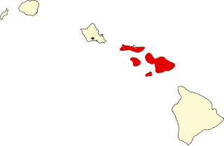
English: This is a locator map showing Maui County in Hawaii. For more information, see Commons:United States county locator maps. |
| Date | |
| Source |
Own work: English: The maps use data from nationalatlas.gov, specifically countyp020.tar.gz on the Raw Data Download page. The maps also use state outline data from statesp020.tar.gz. The Florida maps use hydrogm020.tar.gz to display Lake Okeechobee. |
| Author | David Benbennick |
Laikini
| I, the copyright holder of this work, release this work into the public domain. This applies worldwide. In some countries this may not be legally possible; if so: I grant anyone the right to use this work for any purpose, without any conditions, unless such conditions are required by law. |
Mōʻaukala waihona
Kāomi ma ka lā/hola no ka nānā ʻana i ka waihona ma kēlā manawa.
| Lā/Hola | Kiʻiliʻi | Nā Nui | Mea ho‘ohana | Kaumanaʻo | |
|---|---|---|---|---|---|
| okamanawa | 11:06, 12 Pepeluali 2006 | | 5,663 × 3,681 (23 KB) | David Benbennick | {{subst:User:Dbenbenn/clm|county=Maui County|state=Hawaii}} |
Nā Hana waihona
Loulou kekahi ‘ao‘ao i kēia waihona:
Global file usage
The following other wikis use this file:
- Usage on als.wikipedia.org
- Usage on ar.wikipedia.org
- Usage on bg.wikipedia.org
- Usage on bpy.wikipedia.org
- Usage on ca.wikipedia.org
- Usage on cdo.wikipedia.org
- Usage on da.wikipedia.org
- Usage on de.wikipedia.org
- Usage on en.wikipedia.org
View more global usage of this file.